
Sectors

Basemap

Statuses

104 sites displayed

Kasaï-CentralHaut-KatangaHaut-LomamiIturiKasaïKasaï-OrientalKinshasaKongo-CentralKwangoKwiluLomamiBas-UéléLualabaMai-NdombeManiemaMongalaNord-UbangiNord-KivuSankuruSud-KivuSud-UbangiTanganyikaTshopoTshuapaHaut-UéléÉquateurKasaï-CentralHaut-KatangaHaut-LomamiIturiKasaïKasaï-OrientalKinshasaKongo-CentralKwangoKwiluLomamiBas-UéléLualabaMai-NdombeManiemaMongalaNord-UbangiNord-KivuSankuruSud-KivuSud-UbangiTanganyikaTshopoTshuapaHaut-UéléÉquateurInga 3 — 11 050 MWPioka-Tombe — 6 450 MWZongo-Inkisi — 6 450 MWLuvua — 3 048 MWInga II — 1 424 MWKinsuka — 900 MWChutes Tshungu — 800 MWMambilima Falls — 798 MWWanie Rukula — 700 MWMumbotuta — 510 MWInga I — 351 MWRuzizi 4 et 5 — 267 MWNseke — 248 MWLuvua (Manono) — 242 MWBusanga — 240 MWKibombo — 240 MWChutes Tubila — 223 MWRuzizi III — 206 MWKwango — 180 MWKwilu (Gungu) — 173 MWLulua — 155 MWUélé — 155 MWKimimbi-Fuka — 153 MWÎle des Éléphants — 150 MWZongo II — 150 MWNepoko — 141 MWKwilu (Feshi) — 121 MWNzilo 2 — 120 MWKwenge — 114 MWRuki — 114 MWNzilo — 108 MWBunia — 100 MWcKasaï — 100 MWKisangani — 100 MWcMbuji-Mayi — 100 MWcBandundu — 84 MWcKananga — 84 MWcKolwezi — 84 MWcZongo I — 75 MWMwadingusha — 70 MWKindu — 69 MWcKatende — 64 MWKamina — 60 MWcFungurume — 44 MWcRuzizi II — 44 MWKoni — 42 MWAketi — 31 MWcButa — 30 MWcRuzizi I — 30 MWKongolo — 24 MWcManono — 23 MWcTshopo — 18 MWKahemba — 12 MWcSanga — 12 MWKasumbalesa — 11 MWcKipushi — 11 MWcKisenge — 11 MWcLubumbashi — 11 MWcLwishia — 11 MWcTshinsenda — 11 MWcKakobola — 10 MWN'djili-Brasserie — 1 200 kWButa — 1 000 kWcMiabi P1 — 1 000 kWAthénée de Kananga — 800 kWcMbata Kiela — 600 kWBasankusu — 500 kWcBongandanga — 500 kWcKabare — 500 kWcLusambo — 500 kWcLodja — 400 kWcTshilenge — 400 kWcKongolo — 350 kWcBia Nsiengwom — 300 kWCeni (Bulungu) — 300 kWcKasongo-Lunda — 300 kWcWembonyama — 270 kWcKalehe — 250 kWcAéroport de Kananga — 200 kWcAthénée de Bulungu — 200 kWcFomi — 200 kWcKatanda — 200 kWcLubefu — 200 kWcLuebo 1 — 200 kWcLuebo 2 — 200 kWcLukalaba — 200 kWcMweka — 200 kWcMwene-Ditu — 200 kWcNgandajika — 200 kWcTshimbulu — 200 kWcTshumbe — 200 kWcKalamba — 175 kWcKamonia — 150 kWcTshikapa — 150 kWcLubao — 100 kWcLupatapata — 100 kWcMupompa — 100 kWcWalikale — 50 kWPoko — 40 kWcKabinda — 30 kWLubao (éclairage) — 18 kWUsine de la LukayaUsine de N'djiliUsine de Ngaliema

Colours = sector

HydropowerSolarPower gridDrinking water

Shapes = status

ExistingOngoingPotential

HydropowerOngoing

Inga 3

Grand Inga programme — under development

11 050 MWCapacity

Province
Kongo-Central
Location
Inga
River
Fleuve Congo

Displayed sites, ranked by capacity

The “Existing” and “Ongoing” layers are indicative and will be progressively completed. Rural electrification facilities are positioned on the locality they serve; some locations are approximate at national scale. Estimated potential capacities.

The official maps from the studies

The two reference maps of the national potential, taken from the reports available in our publications.
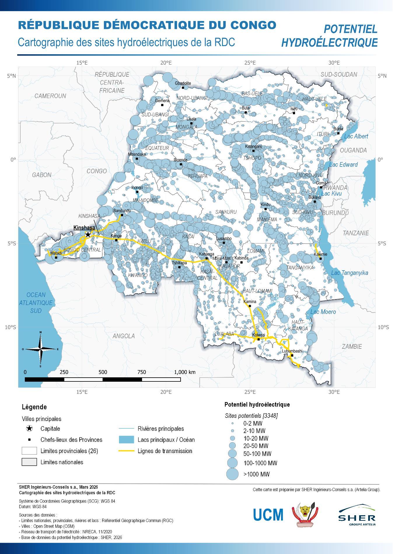
Map of the hydropower potential of the Democratic Republic of the Congo: 3,348 potential sites by capacity class

Hydropower potential

Mapping of the DRC's hydropower sites — UCM / SHER Ingénieurs-Conseils, March 2026.
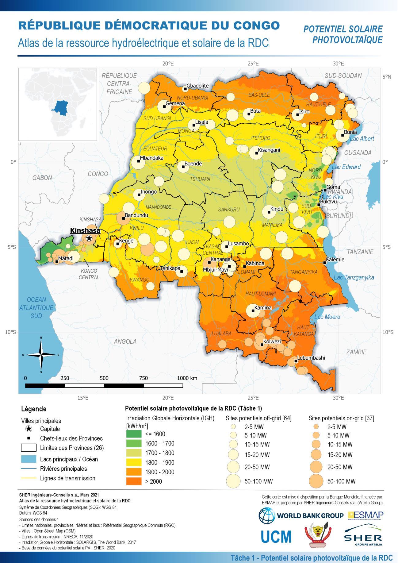
Map of the solar photovoltaic potential of the Democratic Republic of the Congo: irradiation and potential sites

Solar photovoltaic potential

Atlas of the DRC's hydropower and solar resource — World Bank / ESMAP, 2021.

Vous souhaitez investir ?

Notre équipe accompagne les porteurs de projets et les investisseurs à chaque étape. Contactez le Ministère pour engager le dialogue.

Invest in the DRC